The Arctic is warming at rates twice that of the global average, making Arctic ice highly vulnerable to melt. Much of the Arctic is covered in sea ice on the surface of the ocean, but it is the Greenland Ice Sheet—the largest mass of land-based ice in the Northern Hemisphere—that is the focus of the GreenDrill project.
Any melting from the ice sheet moves water directly into the ocean, contributing to global sea level rise and causing devastating effects around the globe. The Greenland Ice Sheet alone holds an estimated 7.4 meters (24 ft) of global sea level equivalent. If even 10% of that ice were to melt, coastal cities and island communities around the world would suffer significant impacts.
While changes in sea level from Greenland ice loss are already being experienced, the estimated contribution rates used in projections for planning and preparedness are very conservative. To effectively plan, we need to move beyond conservative. In this project we examine how the ice sheet has responded to prior warming events, identifying which areas of the ice sheet contributed the first centimeters and meters of sea level rise and over what timescales, so that we can improve our projections and planning.
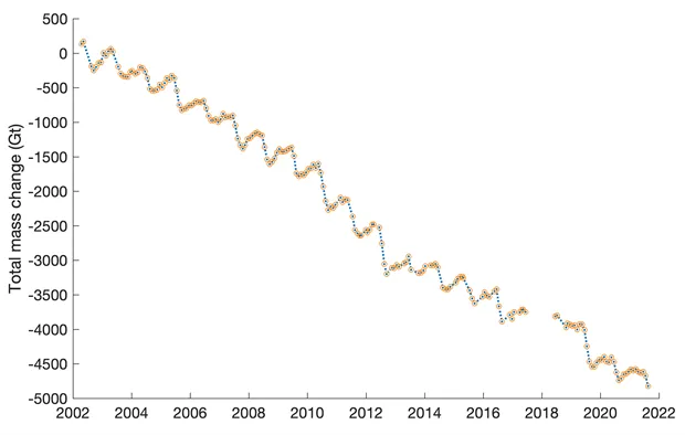
Current data from the 2021 Arctic Report Card (Moon et al. 2021) notes that the 2002-2021 average ice loss for the Greenland Ice Sheet is -264 ± 12 Gigatons (Gt) yr-1. 1 Gt is equal to one billion metric tons, and over the last two decades, Greenland has consistently been losing 264 times that each year, contributing that ice as meltwater to the global ocean.
Overall the prevailing trend has been consistent annual ice loss including both an increasing area of surface ice melt and an increasing number of ice melt days. The result of this trend is the ice sheet is currently contributing about 25% of our annual global sea level rise, with this contribution expected to increase in the future. Changes are growing ever more apparent, with Summit Station Greenland, since 1999 a Long Term Observatory, experiencing the first reported rainfall at this location on August 14, 2021.
Project Goals
Questions that are driving this project include a look into the past to help us identify:
- Which areas of the Greenland Ice Sheet have been the most vulnerable to a warming climate?
- What areas will contribute the first cms of sea level rise?
- How quickly will they begin to respond, and at what rate will the changes occur?
Each question is important to modeling future sea level change, and taken together, they provide the catalyst behind the GreenDrill Project.
We can learn about the future from turning back the clock to look at the past. Greenland’s bedrock surface is an archive of the ice sheet history, however, these answers currently lie buried beneath the ice. To gain access to the answers will require drilling through the ice to the rock beneath. Exposed rock surfaces are archives for cosmogenic isotopes that form when cosmic rays strike the rocks and provide a cosmogenic time stamp or 'clock' for the researchers. Through chemical analysis, the team can determine the last time the rock was uncovered and exposed to the atmosphere.
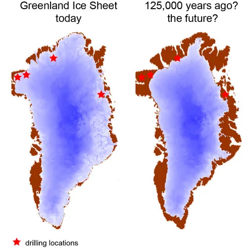
Four different drill locations have been selected, all in northern Greenland where the project team hypothesizes large-scale ice sheet changes will first occur based on evidence from past ice behavior.
Estimates of past ice behavior are shown in the image on the left, representing ice extent during the Eemian, a warm period ~125,000 years ago when climate was just a few degrees warmer than today.
Each location will have a transect of three drill holes moving towards the ice edge. Hole depths will be drilled to 300m, 100m, and a final hole at the exposed ice edge. Samples will then be analyzed to trace the history of the ice sheet in this part of Greenland, providing us insight into what our future for contributions to sea level rise might be.
Learn more about the drill selection process on the Drill Sites page.
GreenDrill is funded under the National Science Foundation (NSF) Office of Polar Programs.