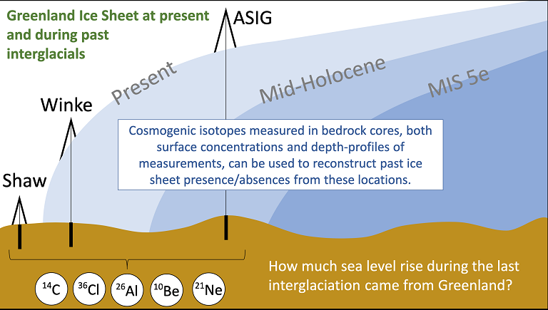
GreenDrill will integrate high-sensitivity, subglacial multi-cosmogenic nuclide analysis with ice sheet models to develop estimates of the Greenland Ice Sheet’s (GrIS) contribution to past sea-level highs.
Cosmogenic nuclides dating is used to constrain the size of the ice sheet, and is effective for timescales of a thousand to ten million years making it an extremely valuable method for tracking glacial cycles. The technique can tell how long the rocks have been located at the surface, and is commonly used to date already exposed bedrock, or glacially transported rocks left behind by the ice as it retreated over the landscape, such as erratics or moraines. For the GreenDrill project, however, we are dating rock that remains buried under the ice where it has been for tens of thousands of years, focusing on past exposure during times of deglaciation. The project builds on recent work (Schaefer et al, 2016) that applied cosmogenic dating of bedrock under the ice at the Greenland Summit from the GISP2 project and showed that Greenland was either ice-free or the ice sheet was significantly smaller sometime during the past 1.1 million years.

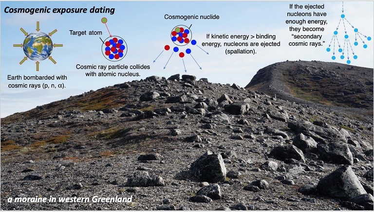
From left to right the graphic shows Earth’s atmosphere under heavy bombardment from cosmic rays. Collisions can cause spallation The first interaction is when the high energy particles collide with nuclei in the upper atmosphere. If there is enough energy in the system they cause a ‘spallation’ breaking apart atoms through a nuclear reaction.
Cosmogenic nuclides are created by cosmic ray bombardment from high-energy particles that flow into our solar system from outer space, moving down to strike the surface of the Earth. Cosmic rays are guided by the Earth’s magnetic field, causing the intensity of their impact with the atmosphere to vary by altitude and also latitude. The flux at the poles is four times more intense than at the equator.
Cosmogenic nuclide dating uses cosmogenic nuclides formed in situ within rocks at the Earth’s surface (within the top few centimeters) when the rock is bombarded by high-energy cosmic rays. As their production slows with depth, measuring nuclides along a depth profile will provide more complete information than a single surface profile at the ice/bed interface. During periods when the ice sheet covered the bedrock surface after an exposure period, the cosmogenic radionuclides decay according to their different half-lives, which allows for dating the burial time of formerly exposed surfaces. If there has been no additional cover or erosion of the sample site during ice-sheet cover, the depth profile should follow a theoretical production profile, telling us exposure history.

This project focuses on a suite of different non naturally occurring isotopes that will be collected from the Greenland bedrock, and dated to determine how the GrIS has responded to climate change in the past. Cosmogenic nuclides in Greenland bedrock are produced during ice-free periods when the surfaces are exposed to the secondary cosmic ray neutrons (strong interaction) and muons (weak interaction) at relatively well-known production rates (see table below).
Table of cosmogenic Isotope ratios systematics
10Be, 26Al,14C and 21Ne are measured form quartz; cosmogenic 36Cl predominantly produced from spallogenic interaction of fast neutrons with potassium and calcium, is measured from feldspar.
Most Earth science research to date has used a series of cosmogenic nuclides produced in quartz (which is widely available) 26Al, 14C and 10Be, that can all be measured together. These three nuclides have distinctly different half-lives, making them a valuable chronometer for exposure of the bedrock surface beneath the ice. 36Cl can be measured in feldspar providing a fourth cosmogenic nuclide with its own unique half-life.
There are challenges with measuring sub-ice samples. Measuring the stable bedrock under the ice is more easily interpreted than measuring loose sediments that can be transported to different locations by the ice sheet. It is possible when examining sub-ice sites that substantial subglacial erosion could have eroded enough of the rock surface to erase the record of subglacial exposure during past interglacial exposure. However, if samples are selected from cold-based ice locations the likelihood of this is significantly reduced.

GreenDrill is funded under the National Science Foundation (NSF) Office of Polar Programs.

