Predicting where the first half-meter to meter of future sea level rise will come from is critical in efforts to mitigate and adapt to serious impacts of anthropogenic climate change. We can use the past to assist by estimating the ice volume that was lost during past warm periods to help understand how the Greenland Ice Sheet (GrIS) might respond to future warming. For the GreenDrill project, we combined ice sheet modeling experiments with high-sensitivity subglacial multi-cosmogenic analysis to develop estimates of the GrIS’s contribution to past sea-level highs.
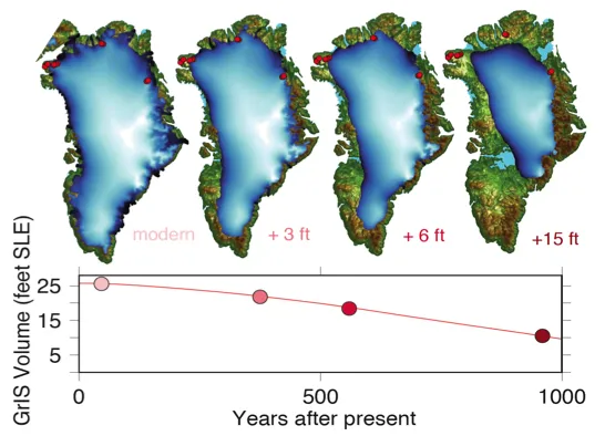
The figure above represents a simulation of the GrIS to an RCP8.5 greenhouse gas emissions scenario over the next thousand years to illustrate the configuration of the ice sheet with 1, 2, and 5 m (3, 6, and 15 ft) contributions to sea level with the red curve representing the remaining ice in meters of sea level equivalent. The image shows that two of the proposed GreenDrill field sites are exposed when the GrIS contributes with the first meter (3 feet) of sea level contribution. Credit: Benjamin Keisling
Previous ice sheet modeling efforts have provided differing responses when predicting where the first meter of sea level will originate, making it difficult to predict which sections of the GrIS margin are most responsive to a warming climate. The GreenDrill project chose to address this through applying an ensemble of GrIS model simulations in order to look at a range of ice sheet responses. This effort used two different starting climatologies, one of modern conditions represented by warmth from greenhouse gasses, and the other a period during the Holocene (~last 11,700 yrs) called the Holocene Thermal Maximum that occurred from about 9000-5000 years ago when the sun’s insolation was unusually strong, peaking ~8,000 BP. These two climatologies provided warming across a range of rates as modern warming has been shown to differ from past warming.
For this work, we ran an ensemble of 96 simulations varying a range of uncertain model parameters describing past rates of interglacial warming that included the initial state of the ice sheet (geometry), the interglacial climatology, solid-Earth coupling (relaxation time of the soft aesthenosphere layer), and precipitation lapse rate. Then, we analyzed this ensemble to predict the contribution of the GrIS to sea level when a currently ice-covered site is ice-free.
We found that different model parameters played a dominant role in different parts of the ice sheet. Along the ice sheet margins the starting climatology and precipitation lapse rates played a larger role, while for inland regions the response of the bed and the initialization geometry was more important. The wider ensemble approach brought in multiple sources of uncertainty with the end result being a map that identified which areas of the GrIS are most vulnerable under different warming scenarios.
The Schaefer et al, 2016 paper on Camp Century, where cosmogenic nuclides indicate the ice sheet was absent within the last one million years, provided a test of the method. For Camp Century to be ice free, our ensemble indicates that Greenland must contribute a minimum of 1.6 meters to global sea level. We note, however, that ice-free conditions at Camp Century do a poor job of constraining the upper limit of Greenland interglacial ice loss.
We applied our method to sites throughout Greenland, focusing on areas where future subglacial access drilling is planned as part of this project, to identify sites that provide tight lower and upper limits on the GrIS contribution to past sea level. In Northeast Greenland, for example, a transect of sites from the margin to ~600 meters ice-thickness reveals that ice-free conditions here imply a sea level contribution of 0.5–3.5 meters.
GreenDrill is funded under the National Science Foundation (NSF) Office of Polar Programs.